Marco Trucchi, Christophe Biondi Pothole Mapper is a service that provides liveupdated maps of road defects like potholes, cracks, and worn portions (along with their precise severity and position) thanks…
Read More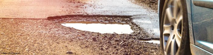
Marco Trucchi, Christophe Biondi Pothole Mapper is a service that provides liveupdated maps of road defects like potholes, cracks, and worn portions (along with their precise severity and position) thanks…
Read More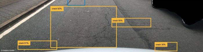
Patrick Glaser Vialytics is a road condition assessment solution powered by a proprietary AI algorithm. It utilises image and vibrational data obtained from on-site municipal vehicles (like sweepers) that are…
Read More
Razvan Suta Polisensio has developed a mobile urban air quality system for monitoring, data collection, analytics, and visualisation that is dedicated to (smart) cities and businesses. First, Polisensio installs its…
Read More
Giampaolo Marinaro Today, many of the location-based services (LBS) related to urban mobility rely on smartphones. The availability of raw GNSS measurements on Android phones has opened up the possibility…
Read More
Prof. Dr. Sebastian Ritterbusch, Stefan Siebert, Harald Kucharek In unfamiliar urban areas, it is often difficult for the blind and visually impaired to find their way around. SafeRoute – Pedestrian…
Read More
Dr. Roland Weesie, Nia Weesie, Sarah Weesie In several terror attacks over the past few years, heavy goods vehicles have been driven into large crowds to inflict maximum damage. In…
Read More
Angelica Valdivia, Dr Jeffrey Wallace, Dr Sara Kambouris, Dr Lukasz Bonenberg, Markus Löning Infinite Dimensions Integration S.L. is creating an intelligent navigation system package for buses supporting current and future…
Read More
Michal Jakob, Jan Hrncir, Pavol Žilecký, Jan Nykl MoveLight will enable seamless integration of bicycles, self-balancing unicycles, hoverboards, and other light personal transporters (LPTs) into intermodal urban transport systems. The…
Read More