Due to the lack of precision farming technologies, farmers mostly spray their entire fields with herbicides even though weeds are only present in specific areas. This causes unnecessary costs and…
Read More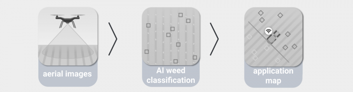
Due to the lack of precision farming technologies, farmers mostly spray their entire fields with herbicides even though weeds are only present in specific areas. This causes unnecessary costs and…
Read More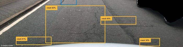
Patrick Glaser Vialytics is a road condition assessment solution powered by a proprietary AI algorithm. It utilises image and vibrational data obtained from on-site municipal vehicles (like sweepers) that are…
Read More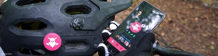
Andreas Botsch The Tocsen system consists of a smartphone app and a crash sensor which is mounted to the helmet of a cyclist. The system analyses a crash and calls…
Read More
Prof. Dr. Sebastian Ritterbusch, Stefan Siebert, Harald Kucharek In unfamiliar urban areas, it is often difficult for the blind and visually impaired to find their way around. SafeRoute – Pedestrian…
Read More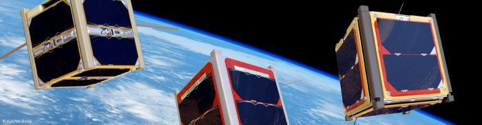
Andreas Hornig, Sebastian Kühn, Alexandros Kazantzidis, Jay Krishna, Timm Eversmeyer Mini-satellites, laptop satellites, cubesats and other concepts reflect a new type of satellite: Cheap, easy to realise and easy to…
Read More
Rainer Schrode, Ulrike Nohlen, Dr Alexander Beetz The civil engineering 3D+ guide developed by MTS defines data formats and digital construction processes from planning to billing in conjunction with the…
Read More
Dr Walter Naumann On planet Earth, the well-being of humans is directly connected to the existence of animals, be it as a source of food, the origin and carrier of…
Read More
Prof Dr Reiner Jäger, Julia Diekert, Andreas Hoscislawski, Jan Zwiener, Stephan Batke, Axel Lorenz The expansion of GNSS, such as through Galileo and global positioning services, has made satellite positioning…
Read More
Erich H. Franke, Roswitha M. Franke, Patrick Böer, Gerald Meyer, Xavier Groelly Winter road service is an important issue in the field of traffic safety. It is also a cost-intensive…
Read More
Dr Georgios Papastefanou, Hartmut Gündra EmoCityMap (Emotional City Mapping) is a new technology for measuring people’s emotions in situ. It extends socio-physical features based on geographical information systems (GIS) by…
Read More