Perfect Sense AQ is a pollution-sensing pin badge and application that provides customised insights to help users understand the air quality in their surroundings and take action to protect their…
Read More
Perfect Sense AQ is a pollution-sensing pin badge and application that provides customised insights to help users understand the air quality in their surroundings and take action to protect their…
Read More
MALO is an application that aims to improve orientation in underground transportation with fast and accurate GNSS maps. The solution integrates the Galileo system with Bluetooth mesh-network technology using pseudolites,…
Read More
Farming and food security are facing many challenges that are expected to increase in the future due to growing populations, the decreasing number of people working in agriculture, and growing…
Read More
Soilspect is a product that was developed for automatic monitoring of ground compaction using GNSS positioning. Before a road or another major construction is built, the ground needs to be…
Read More
The Galileo Public Regulated Service (PRS), the flagship service of Galileo, is an encrypted navigation service for governmental users and sensitive applications. It offers high resilience to jamming and spoofing,…
Read More
The system developed by Truckscreenia is a real-time adaptive advertising tool that exploits GNSS positioning and artificial intelligence in combination with proprietary advanced georeferencing technology. The advertising devices are installed…
Read More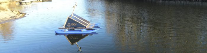
WAMO is a real-time surface water assessment platform for flood warnings and algal monitoring and control. The free-floating platform integrates different sensors for accurate and real-time parameter observation. These sensors…
Read More
GASPP is a GNSS positioning solution that can achieve high accuracy in real-time for precise smartphone positioning applications. As more than 70% of smartphone applications use location-based services (LBS), the…
Read More
ADAGIO is a Galileo-powered service that was developed to improve attitude and orbit determination in CubeSats. CubeSats are small, low-cost satellites designed and operated mainly by small companies, startups, and…
Read More
Nav4you is an AI-driven tool that was developed to ensure the safety of security and emergency service operators in dangerous environments. It features an innovative and compact location device that…
Read More